Storms › 2026
Hurricane Vance (2026)
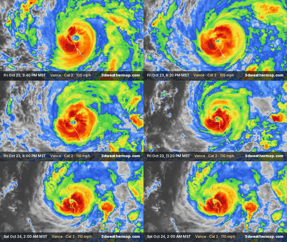
Replays Vance's whole life from our archive — satellite cloud tops all the way, NHC track — in about 30 seconds; or jump to a highlight.
Summary
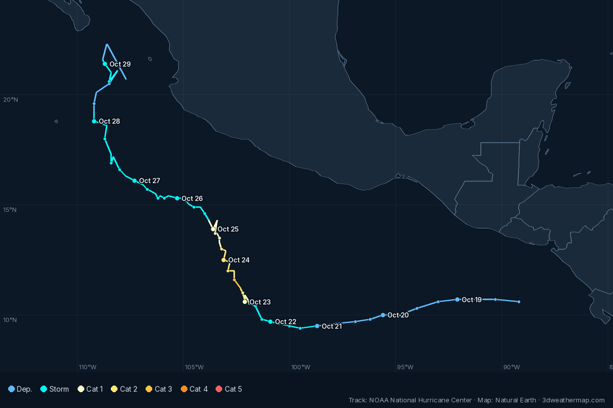
The National Hurricane Center (NHC) began advisories on Tropical Depression Twenty-Two-E at 8:00 AM MST Wed, Oct 21, 2026, when it was 515 mi S of Acapulco Mexico, with maximum sustained winds of 35 mph.
It strengthened into Tropical Storm Vance at 2:00 PM MST Wed, Oct 21 and became a hurricane at 2:00 AM MST Fri, Oct 23.
Its highest maximum sustained winds in NHC products were 110 mph (175 km/h), Category 2, at 8:00 PM MST Fri, Oct 23; the lowest central pressure reported was 965 mb (28.50 inches), at 8:00 PM MST Fri, Oct 23.
NHC's last product on Vance was Remnants Of Vance Advisory Number 35, issued at 8:00 PM MST Thu, Oct 29, 2026.
From NHC public advisories and updates. Operational values — NHC's final best-track report may revise them.
Track
Remnants
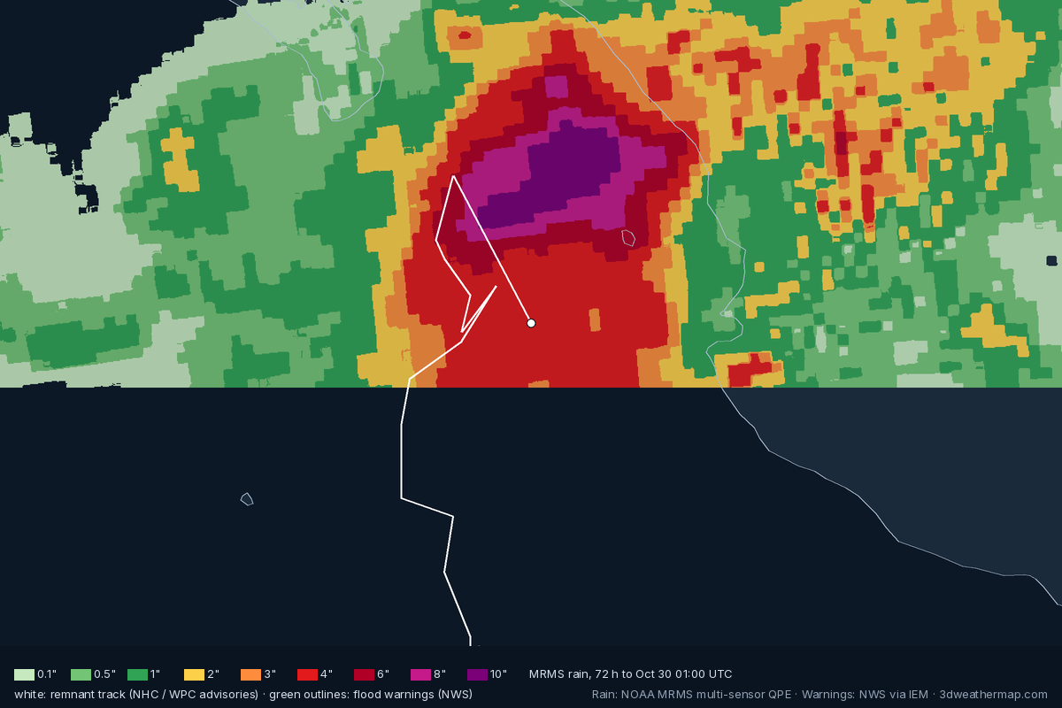
After NHC's final advisory (8:00 PM MST Thu, Oct 29) the remnants are followed by NOAA's Weather Prediction Center; heavy rain and flooding can go on far inland. Facts below come from WPC advisories, NWS flood warnings along the remnant track (within ~190 mi) and NOAA MRMS radar-and-gauge rain estimates.
NHC advisory timeline
| Issued (MST) | NHC | Status · headline | Winds | Pressure | Position · motion |
|---|---|---|---|---|---|
| 8:00 PM MST Thu, Oct 29 | Adv. 35 | RemnantsVANCE NO LONGER HAS A WELL-DEFINED CENTER AND THIS IS THE FINAL NHC ADVISORYREMNANT MOISTURE EXPECTED TO SPREAD INTO PORTIONS OF THE SOUTH-CENTRAL AND SOUTHWESTERN UNITED STATES | 30 mph | ||
| 2:00 PM MST Thu, Oct 29 | Adv. 34 | Tropical DepressionVANCE WEAKENS WHILE CONTINUING NORTHWARD NEARING THE GULF OF CALIFORNIAMOISTURE FROM VANCE WILL SPREAD INTO PORTIONS OF THE SOUTH-CENTRAL AND SOUTHWESTERN UNITED STATES | 35 mph | ||
| 8:00 AM MST Thu, Oct 29 | Adv. 33 | Tropical StormFLOOD AND MUDSLIDE THREAT CONTINUES FOR MEXICO DUE TO VANCEMOISTURE FROM VANCE WILL SPREAD INTO PORTIONS OF THE SOUTH-CENTRAL AND SOUTHWESTERN UNITED STATES | 40 mph | ||
| 2:00 AM MST Thu, Oct 29 | Adv. 32 | Tropical StormFLOOD AND MUDSLIDE THREAT CONTINUES FOR MEXICO DUE TO VANCE | 40 mph | ||
| 8:00 PM MST Wed, Oct 28 | Adv. 31 | Tropical DepressionSHOWER AND THUNDERSTORM ACTIVITY REDEVELOPS NEAR VANCE | 35 mph | ||
| 2:00 PM MST Wed, Oct 28 | Adv. 30 | Tropical DepressionVANCE WEAKENS TO A TROPICAL DEPRESSION | 35 mph | ||
| 8:00 AM MST Wed, Oct 28 | Adv. 29 | Tropical StormVANCE REMAINS A HIGHLY SHEARED TROPICAL STORM | 40 mph | ||
| 2:00 AM MST Wed, Oct 28 | Adv. 28 | Tropical StormVANCE HOLDING STEADY ON A NORTHWARD TRACK | 40 mph | ||
| 8:00 PM MST Tue, Oct 27 | Adv. 27 | Tropical StormVANCE CONTINUES TO MOVE SLOWLY TO THE NORTHWEST | 40 mph | ||
| 2:00 PM MST Tue, Oct 27 | Adv. 26 | Tropical StormVANCE HOLDING STEADY OFFSHORE OF SOUTHWESTERN MEXICO | 40 mph | ||
| 8:00 AM MST Tue, Oct 27 | Adv. 25 | Tropical StormVANCE IS A POORLY ORGANIZED TROPICAL STORM | 40 mph | ||
| 2:00 AM MST Tue, Oct 27 | Adv. 24 | Tropical StormVANCE WEAKENS SLIGHTLY | 45 mph | ||
| 8:00 PM MST Mon, Oct 26 | Adv. 23 | Tropical StormVANCE DRIFTS WESTWARD AND WEAKENS | 50 mph | ||
| 2:00 PM MST Mon, Oct 26 | Adv. 22 | Tropical StormVANCE JOGS WESTWARD AND MAINTAINS INTENSITY FOR NOW | 65 mph | ||
| 8:00 AM MST Mon, Oct 26 | Adv. 21 | Tropical StormVANCE MOVING SLOWLY WEST-NORTHWESTWARD AND LIKELY TO WEAKEN | 65 mph | ||
| 2:00 AM MST Mon, Oct 26 | Adv. 20 | Tropical StormVANCE MOVING SLOWLY NORTHWESTWARD AND LIKELY TO WEAKEN | 65 mph | ||
| 8:00 PM MST Sun, Oct 25 | Adv. 19 | Tropical StormVANCE CONTINUES TO WEAKEN AS THE STORM MOVES TO THE NORTHWEST | 65 mph | ||
| 2:00 PM MST Sun, Oct 25 | Adv. 18 | Tropical StormTROPICAL STORM VANCE CHURNING OFF THE COAST OF SOUTHWESTERN MEXICO | 70 mph | ||
| 8:00 AM MST Sun, Oct 25 | Adv. 17 | Hurricane (Cat 1)VANCE CONTINUES TO WEAKEN | 75 mph | ||
| 2:00 AM MST Sun, Oct 25 | Adv. 16 | Hurricane (Cat 1)VANCE WEAKENS SLIGHTLY | 85 mph | ||
| 8:00 PM MST Sat, Oct 24 | Adv. 15 | Hurricane (Cat 1)VANCE HOLDS STEADY WHILE DRIFTING NORTH-NORTHWESTWARD | 90 mph | ||
| 2:00 PM MST Sat, Oct 24 | Adv. 14 | Hurricane (Cat 1)VANCE WEAKENS SOME MORE AS IT CONTINUES NORTH-NORTHWESTWARD | 90 mph | ||
| 8:00 AM MST Sat, Oct 24 | Adv. 13 | Hurricane (Cat 2)VANCE WEAKENS A LITTLE AS IT MOVES SLOWLY NORTH-NORTHWESTWARD | 105 mph | ||
| 2:00 AM MST Sat, Oct 24 | Adv. 12 | Hurricane (Cat 2)VANCE HOLDING STEADY | 110 mph | ||
| 8:00 PM MST Fri, Oct 23 | Adv. 11 | Hurricane (Cat 2)VANCE NEAR MAJOR HURRICANE STRENGTH | 110 mph | ||
| 2:00 PM MST Fri, Oct 23 | Adv. 10 | Hurricane (Cat 2)VANCE STRENGTHENING QUICKLY AND COULD BECOME A MAJOR HURRICANE TONIGHT | 105 mph | ||
| 8:00 AM MST Fri, Oct 23 | Adv. 9 | Hurricane (Cat 1)VANCE CONTINUING TO INTENSIFY | 90 mph | ||
| 2:00 AM MST Fri, Oct 23 | Adv. 8 | Hurricane (Cat 1)VANCE BECOMES A HURRICANERAPID INTENSIFICATION EXPECTED TO CONTINUE TODAY | 85 mph | ||
| 8:00 PM MST Thu, Oct 22 | Adv. 7 | Tropical StormVANCE STRENGTHENING AS IT MOVES NORTHWESTWARDRAPID INTENSIFICATION EXPECTED DURING THE NEXT DAY OR SO | 70 mph | ||
| 2:00 PM MST Thu, Oct 22 | Adv. 6 | Tropical StormVANCE CONTINUES TO STRENGTHEN | 65 mph | ||
| 8:00 AM MST Thu, Oct 22 | Adv. 5 | Tropical StormVANCE GETTING STRONGER WELL SOUTH OF MEXICO | 60 mph | ||
| 2:00 AM MST Thu, Oct 22 | Adv. 4 | Tropical StormVANCE STRENGTHENING AS IT MOVES WESTWARD | 50 mph | ||
| 8:00 PM MST Wed, Oct 21 | Adv. 3 | Tropical StormVANCE STRENGTHENS SLIGHTLYFORECAST TO RAPIDLY INTENSIFY | 45 mph | ||
| 2:00 PM MST Wed, Oct 21 | Adv. 2 | Tropical StormDEPRESSION STRENGTHENS INTO TROPICAL STORM VANCEFORECAST TO RAPIDLY INTENSIFY | 40 mph | ||
| 8:00 AM MST Wed, Oct 21 | Adv. 1 | Tropical DepressionTROPICAL DEPRESSION FORMS SOUTH OF SOUTHERN MEXICOFORECAST TO RAPIDLY INTENSIFY | 35 mph |
About this page
Built automatically from National Hurricane Center products (public advisories, intermediate advisories and tropical cyclone updates, linked above), NOAA GOES satellite imagery and NOAA MRMS radar. Times are MST (UTC-7), as in NHC's products.